
Keetmanshoop Floodline in Tseiblaagte
Client
Keetmanshoop MunicipalityLocation
//Karas, NamibiaHighlights
- Detailed LIDAR survey
- Catchment area analysis
- Detailed hydrology study
- Floodline analysis
- Flood mitigation review
- Stormwater channel design
- Cost estimate for channel construction
Project Overview
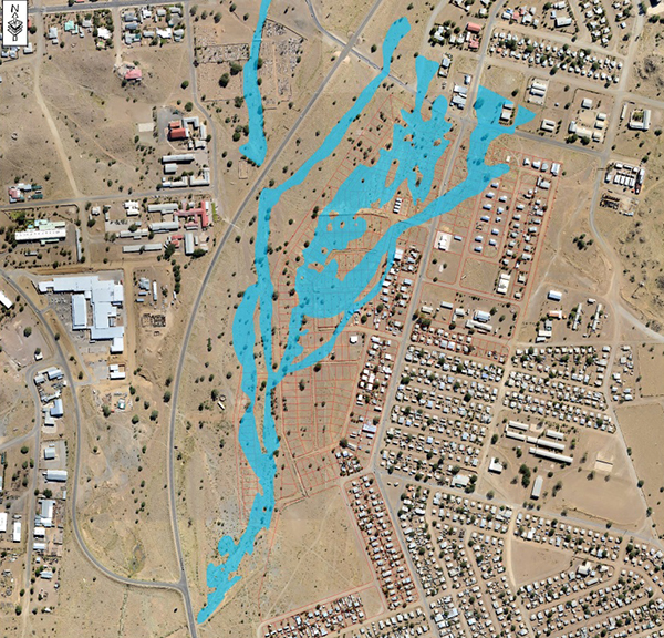
The project is located in Tseiblaagte area in Keetmanshoop, in the south of Namibia. The Municipality of Keetmanshoop started with township development, Tseiblaagte Extension 2, in an area prone to overland flooding. During construction of the roads and water reticulation networks, a high intensity rainstorm caused flooding of the construction site, raising concerns for the safety of future residents.
Knight Piésold was requested to investigate the flood risk in Tseiblaagte and present a solution for future flooding. The study included a high definition aerial survey to identify the catchment areas, a flood hydrology study, and a design of a system to safely pass floodwater through the area.
Project Role
Knight Piésold presented an approach to solve the Tseiblaagte flooding to the client. After appointment, the first step was to get a detailed aerial survey of the entire townlands and wider catchment area draining through the Tseiblaagte area. Thereafter, a flood analysis of two specific catchment areas, which join within the new township, was performed and the 10-, 20-, 50- and 100-year flood sizes were determined. The 50-year return flood, a national standard for high-risk floods, was selected since lives will be at stake once the area becomes populated. Alternative channel routes were investigated to capture and convey the water downstream of Tseiblaagte. The preferred option was presented to the client. The client accepted the option presented and proposes to implement it in the near future.